
- Tarique Rahman returns home amid rapturous reception |
- Home After 17 Years: Tarique Returns to Gulshan Residence |
- Tarique Calls for United Effort to Build a Safe Bangladesh |
- Tarique leaves for 300 feet area from airport |
- BNP top leaders welcome Tarique Rahman on homecoming |
Late action at Dumbur Dam made flood devastate BD suddenly
Tripura Floods: Questions over Disaster Management - SANDRP
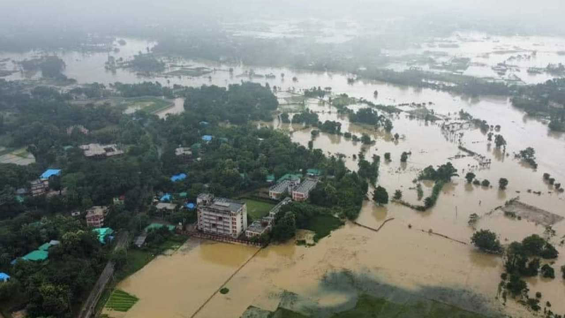
An aerial view of flood affected Feni on Friday.
Tripura is facing one of its worst floods affecting all districts, at least since 19th August. According to latest estimates, at least 22 people have lost life, 65400 people are in 450 relief camps, landslips at 2032 locations, 1.25 lakh ha crops submerged among other extensive damage. Total of around 1.7 million people or about 40% of state pulation are affected. 11 NDRF, 26 SDRF and other emergency service teams are involved in rescue and relief works. The actual rainfall that started on Aug 19 gave enough warning for the state to prepare for the approaching disaster, but once again disaster management has failed to respond using this warning.
It is clear that rainfall during three days of Aug 20-22 that started from 8.30 am on Aug 19 provided enough advance information for the state and central authorities to prepare for the impending flood disaster. In fact the intense rainfall in South Tripura, that got the highest rainfall among all 8 districts of Tripura during this period, actually started on Aug 18 as IMD reported rainfall of 51.7 mm for this district on Aug 19. This means at least for South Tripura the warning bells should have rung starting Aug 18. But from the way situation has panned out, it is clear that the state or the central agencies were caught totally unawares till the floods hit the state from Aug 21 and 22.
River water levels are above the HFL (Highest Flood Level) or Danger level in South Tripura, Sepahijala, West Tripura, Dhalai, Unakoti, Gomati, North Tripura and Khowai districts. According to CWC’s flood forecasting department:
• HFL CROSSED: For example, Haora river at Haora in W Tripura district crossed the HFL of 12.4 m (attained on Aug 11 2017) and reached 12.42 m at 0400-0700 hrs on Aug 22.
• However, glaringly, the Dumbur of Gumti dam, the biggest dam of Tripura, is not part of CWC’s flood forecasting. Even among the sites that are listed on CWC’s flood forecasting in Tripura, a number of sites are not even working. Even for the Amarpur site on Gumti river that is part of India-Bangladesh agreement for flood information sharing, the site did not function between 1600 hrs on Aug 21 and 0600 hrs on Aug 23, the most crucial flood period, when the site is likely to have crossed the HFL. The Sonamura-2, Feni, Sabrum, Kadamtala and Manughat are some of the sites which are either not functioning or crucial information is missing.
• Dumbur Dam: Why no advance water release action? Dumbur or Gumti dam of Tripura is the biggest dam of the state with 30 m height and 103 m length. Spillway capacity is 481.38 cumecs. Reservoir area is 0.709 sq km as per. CWC’s National Register of Large Dams dated Sept 2023. As per the Tripura State Electricity Corporation Ltd website[i], Gumti is a 15 MW project with the third 5 MW unit commissioned in 1984 and first two in 1976. It says: “The yearly energy content in the reservoir of Gumti project is only 60 Million units. Normally 2 units of 5MW each run at a continuous load of 8 MW and the 3rd one is kept as stand by.” The Gumti reservoir Minimum Draw Down Level is 83.6 m and FRL 93.55 m (energy content 85 Million Units (MU)). So this huge dam with massive reservoir area is supposed to be producing just 8 MW power.
• According to North East Region Load Despatch Centre website’s daily power supply position report[ii] Gumti HEP generated no power on Aug 22. The reservoir level on Aug 21 was 92.7, on Aug 16-20, around 92.5 m. Strangely, the reservoir level was shown “Zero” on Aug 21 and 22 which clearly seems wrong. The website says Gumti HEP generated no power on Aug 21, 22. On Aug 20 it generated 0.01 MU, on Aug 16-19 0.05 MU daily. So even in peak monsoon months with high water flow in the river, the dam was not generating almost any power. Why was the reservoir storing so much water in that case?
• Contradicting NERLDC about zero storage on Aug 21-22, the Central Water Commission’s weekly reservoir Bulleting for Aug 22, 2024[iii] showed that Gumti Reservoir had water level at 92.6 m, equal to live storage of 0.268 BCM (Billion Cubic Meters), that is 86% of live storage (out of 0.312 BCM at Full reservoir level of 93.55 m) on Aug 22 2024.
• Leaving aside the controversy about claim of Bangladesh that Dumbur dam releases brought floods in Bangladesh, the first question that arises is why did the dam not start releasing water starting from Aug 19 morning when dam was almost full and high rainfall had already started? Here we are not talking about action based on rainfall forecast, but based on actual rainfall in the catchment, which is surely going to end up in the river and reservoir.
• It could have started releasing water taking into account the downstream river carrying capacity and expected inflows into the dam based on the rainfall that was already happening in the catchment, for which it must be getting hourly data. That could have helped provide at least a few hours (it can be even few days depending on the extent of advance action) of respite to the downstream area which could have been used to alert and prepare the downstream area. It would have helped Tripura too since the river travels 120 km downstream in Tripura before it enters Bangladesh.
• India’s Ministry of External Affairs clarified on Aug 22 2024 through a Press Statement[iv]: “We have seen concerns being expressed in Bangladesh that the current situation of flood in districts on the eastern borders of Bangladesh has been caused by opening of the Dumbur dam upstream of the Gumti River in Tripura. This is factually not correct. We would like to point out that the catchment areas of Gumti river that flows through India and Bangladesh have witnessed heaviest rains of this year over the last few days. The flood in Bangladesh is primarily due to waters from these large catchments downstream of the dam.” While this is correct, if we had taken advance action of water release from Dumbur dam taking the high rainfall already happening, it would have helped both countries. Particularly when the dam is not even producing any significant amount of power.
• Information about the disaster The FB page of Tripura Disaster Management Authority[v] has not been updated since Aug 16 as we write this.
• Tripura Disaster Management Authority website[vi] provided no updates about the flood disaster till Aug 23 as we write this. Even on TDMA’s official facebook page[vii], there is no update regarding the disaster except one post with 3 photos on Aug 22. However, there are more updates about this disaster on Tripura Govt’s FB page[viii], however, large number of them are focussed on the visits of the Chief Minister Dr Manik Saha rather on the flood situation.
• However, interestingly, the FB page of Gomati district magistrate had frequent and useful updates about developing flood situation in the district, some of them are given below.
• On Aug 20 2024, 6.19 PM, Gomati District Magistrate conveyed “Dumbur Dam Alert” on FB[ix]: “Water from Dumbur Hydroelectric Project Dam has to be released as water has accumulated to the critical level giving no scope to TPGL but to release some water. Requesting all citizens concerned and downstream Districts of the state to take precautionary measures immediately.” As the FB page says, this is the “Official Facebook Page of District Administration, Gomati District, Udaipur”.
• Alert at 5 pm, Aug 21 2024: “Two nos. Flap gates fully & one gate partially (50%) (automatically) discharging water from reservoir.” At 8:35 am of 21st August
• One flap gate (out of 3) have been opened.
• 14.45 hrs, Aug 21 2024: Water Level of Gomati River at Udaipur Gauge Station (near Subhash Bridge): Extreme Danger Level crossed in the afternoon today. Extreme Danger level: 22.00 m – Present level: 22.05 m (Time: 14.45 hours); 21.9 m at 10.30 hrs; 21.8 m at 0945 hrs; 21.7 m at 0825 hrs.
• Water level of Gomati river at Amarpur gauge station (near Rangamati bridge): Extreme Danger level= 32.00 m – Present water level at 8 am on Aug 22: 31.94m
• Many questions have been raised here about the disaster management during the current Tripura flood disaster. The question is are we doing anything to address these issues and improve our disaster management? This becomes pertinent when we realise the increasing frequency of high intensity rainfall events and extreme flood situations we are increasingly facing. These questions are relevant for Dumbur dam, but also for the disaster management across the state.
• SANDRP (ht.sandrp@gmail.com)