
- Dhaka, Beijing sign 13 MoUs to deepen cooperation across key areas |
- China Eyes Teesta Project, Trade Boost With Bangladesh |
- PM Tarique, Li Qiang Hold Bilateral Talks in Beijing |
- Bangladesh’s external debt stands at $78.22 billion: Khosru |
- PM invites Chinese cos to expand value chains into Bangladesh |
Tsunami Alert Proves Value of Global Warning Systems
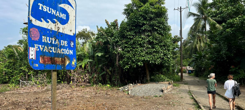
A sign on the Pacific coast of Colombia, shows a tsunami evacuation route.
Early warning systems were activated overnight across Pacific coastal communities after a massive earthquake in eastern Russia triggered a sea surge that reached the Japanese coastline—around 1,000 kilometres (620 miles) away—within about an hour, disaster relief experts said on Wednesday.
While the UN-backed International Atomic Energy Agency (IAEA) reported no damage to Japan’s nuclear facilities following the 8.8-magnitude quake off Russia's Kamchatka Peninsula, coastal communities took no chances, evacuating to higher ground or moving further inland.
Alerts were sent out within minutes of the quake, the UN Office for Disaster Risk Reduction (UNDRR) confirmed. Although the threat has now been downgraded across Japan—where waves as high as 1.3 metres (4ft 2in) were recorded—residents were advised to remain in shelters until the risk from continuing sea surges subsides.
“It is very complex; we are observing the tsunami data in real time, so we need people to stay at the shelter until the tsunami is completed,” said tsunami engineer Professor Fumihiko Imamura of Tohoku University.
In Japan, memories remain vivid from the 11 March 2011 Tohoku earthquake and tsunami, which killed more than 18,000 people.
Just last year, the 7.6-magnitude Noto quake claimed around 500 lives and damaged 150,000 homes. That disaster also triggered a major accident at the Fukushima Daiichi Nuclear Power Plant, forcing tens of thousands from their homes.
Wednesday's quake ranks among the ten most powerful ever recorded, prompting close monitoring by global authorities.
So far, tsunami alerts have been issued off the west coast of the United States, across South America from Chile to Mexico, and across parts of the Pacific including Papua New Guinea and Vanuatu.
“A magnitude 8.8 earthquake is very large,” explained Kamal Kishore, Special Representative of the UN Secretary-General for Disaster Risk Reduction. “At each step from magnitude seven to eight or eight to nine, the strength increases exponentially. So an eight is about 30 times more powerful than a seven.”
Speaking to UN News, Mr. Kishore highlighted the immense distances tsunamis can travel, carrying vast energy that is later unleashed on coastal communities.
Tsunamis can move as fast as passenger jets and are tracked by deep-sea pressure sensors—called tsunameters—connected to surface buoys. These buoys relay data in real time to satellites, allowing national weather centres to model the threat and issue alerts accordingly.
“It’s a real threat because tsunamis travel very fast from one coast to the other,” he added. “The Indian Ocean tsunami of 2004 was one of the most devastating in our memory. It travelled from the coast of Indonesia to the Sri Lankan shores in just over an hour.”
In addition to UNDRR's coordination role in the global early warning system, other key UN bodies involved include the World Meteorological Organization (WMO) and the Intergovernmental Oceanographic Commission of UNESCO (UNESCO-IOC).
The IOC plays a critical role in ensuring that countries using tsunami-tracking technology adhere to common standards.
These efforts support the UN Secretary-General’s Early Warnings for All initiative, which aims to ensure that everyone on Earth is protected from hazardous weather, water, or climate events through lifesaving early warning systems.
Currently, one in three people—mainly in least developed countries and Small Island Developing States—lacks access to adequate multi-hazard early warning systems.
“Tsunami prevention really highlights the importance of multilateral action,” said Mr. Kishore, stressing the need to share real-time data that powers wave-modelling algorithms.
“There are countries separated by thousands of kilometres of ocean, but affected by the same hazard,” he continued. “If we don’t share information about these hazards—not just where they occur, but also from intermediate ocean locations—we won’t be able to warn our citizens in time.”