

- ADB Approves $100m Loan for Affordable Housing in Bangladesh |
- No Respite From Poisonous Air: Radical Cure Urgent |
- Minimising The Energy Shocks In Bangladesh |
- How Bad Loans, Capital Erosion Pressure Banks In BD |
Nepal’s Rasuwa flood disaster: Is there a limit to Human Folly?
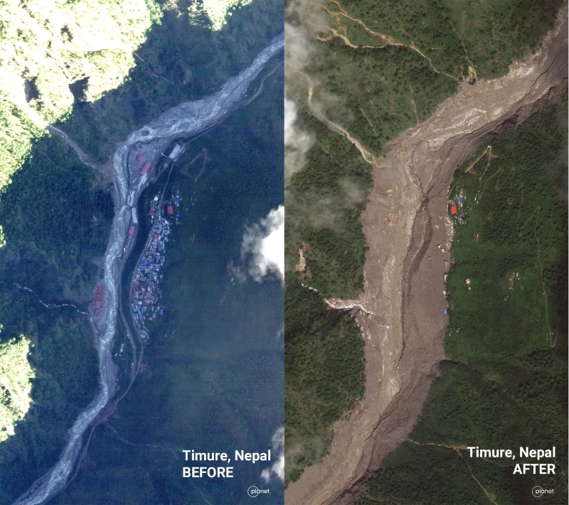
Satellite imagery shows Timure, Nepal, before and after the catastrophic flood. - Planet Labs PBC
August 31, 2026SANDRP
Even as Nepal, Tibet, India and other countries whose citizens are in missing list following the Aug 26 2026 Rasuwa flood disaster for Nepal, and even as the full dimensions of the disaster are still unfolding, a Bloomberg journalist asked SANDRP a pertinent question. Seeing the major role played by operating and under construction hydropower projects in the disaster and the missing list of hundreds of people from such projects, he noted that deaths at disaster hit hydropower projects in Himalayas is a recurring story. During and after every such disaster, there is talk of learning lessons such projects, but there is little change in decision making process. His question was, is there a limit to human folly, beyond which we will see some genuine change?
It’s a tough question. Unfortunately, as of now no limit to human folly is in sight. If we see what has been happening during and post disasters since at least the Kedarnath disaster in June 2013 to the most recent Rasuwa flood disaster, we see little impact of lessons from any of the disasters on the decision-making process of hydropower and such major infrastructure projects in the Himalayas.
If we are really interested in learning lessons from the disasters, the first step we need to do is to set up an independent panel of experts that will try to understand what exactly happened in the disaster, which institutions, individuals, various infrastructure played what role, who needs to be held accountable for major mistakes during the disaster, and what we can learn lessons for future. By not having any such assessment for any of the disasters, we have shut the door on learning any lessons from the disasters. The first thing we need to do is to open that door.
NEPAL DISASTER
Himalayan Disaster: August 2026 Bhote Koshi Deluge On the Himalayan disaster of Aug 26, 2026, this SANDRP report tries to put together the available information in a comprehensive way. It also highlights how ADB and other multilateral institutions are pushing large hydro and related infrastructure in this fragile Disaster-Prone Himalayan region without even adequate assessments and calling it climate resilient project. This very region faced similar GLOF related disaster just a year back on July 8, 2025, but there is no evidence of any lessons learnt. Will we learn any this time?
Nepal Disaster & Hydropower: How Global Banks Downplayed the Risks they Knew This report from SANDRP shows the role of international financial bodies in pushing huge investments in highly risky hydropower projects in the fragile, Himalayan, disaster prone trans-boundary Trishuli-Bhote Koshi basin. They were fully aware of the disaster prone area and still took no steps to address the risks, take preventive measures or avoid and discourage these particularly in monsoon months.
The international financial bodies that have invested in hydropower projects here include Asian Development Bank, World Bank’s International Financial Corporation, Asian Infrastructure Investment Bank, Chinese Exim Bank, and several climate funds and institutes including those from Canada, Netherlands, UK, South Korea and OPEC fund. Will this be a watershed movement in history of hydropower projects in South Asia?
SANDRP researchers Parineeta Dandekar and Himanshu Thakkar argue that this tragedy was not entirely unforeseeable, pointing out that “Multilateral Development Banks including the ADB and World Bank Group’s IFC, that financed and championed the Upper Trishuli-1 hydropower project and conducted a Cumulative Impact Assessment of Trishuli Basin were acutely aware of the extreme danger to which they were exposing thousands of laborers, officials, residents, rivers, infrastructure and landscape.”
The authors note that the lenders’ “own reports repeatedly highlighted it. But they did not take any preventive steps, did not demand stringent checks and balances, nor were they prepared for a calamity they knew could occur,” adding that capital continued to flow under the dubious premise that “Funding was sought and provided in the garb of ‘Climate and Disaster Resilience’.”
Why Earlier Warnings Were Ignored Exactly one year ago, in July 2025, a similar disaster struck this very Bhote Koshi-Trishuli Valley in Nepal’s Rasuwa District, which caused massive damage to more than 10 hydropower projects. In August 2026, a terrifying catastrophe has struck the exact same spot once again.
The question is clear—when scientists and experts have been issuing constant warnings, why weren’t early warning systems and real-time data sharing implemented? When will the blind race to build dams indiscriminately on sensitive Himalayan rivers come to a halt? Hear the sharp and candid words of river and dam expert Himanshu Thakkar (SANDRP) on how administrative negligence invited this devastation all over again.
Flood damage to Nepal’s hydropower sector could run into billions The scale of the destruction has also raised urgent questions over how damaged projects will be rebuilt and who will bear the cost. Rajan Dhakal, spokesperson for the Nepal Electricity Authority (NEA), said on Aug. 28 that the authority’s preliminary assessment pointed to losses worth hundreds of billions of rupees. His estimate is substantially higher than that of the Independent Power Producers’ Association, Nepal (IPPAN), whose senior officials have put average losses in the sector at around Rs25 billion to Rs30 billion.
Uttam Bhlon Lama, senior vice-president of IPPAN, said older hydropower projects with ground-level powerhouses suffered extensive or complete damage. “Newer projects with underground powerhouses and desanders have suffered comparatively less damage,” Lama said. “Overall, we estimate losses at around 25 to 30 percent of the total project cost, although a complete assessment is still pending.”
At least 13 hydropower projects, both operational and under construction, have been damaged in Rasuwa and Nuwakot districts. Affected operational projects include the 20MW Langtang Khola project, which was in the testing phase, the 5MW Mailung Khola, 14.8MW Mailung Khola, a 25MW solar project operated by the NEA and its subsidiaries, the 14MW Devighat, 24MW Trishuli, 60MW Upper Trishuli A, 22MW Chilime and the 111MW Rasuwagadhi Hydropower Project.
Projects under construction that have been affected include the 37MW Upper Trishuli 3B, jointly owned by the NEA and Nepal Telecom, the privately developed 120MW Rasuwagadhi Bhotekoshi, the 6.42MW Upper Mailung A, the 216MW Upper Trishuli 1 and the 15.6MW Middle Trishuli Ganga project.
Insurance could play a crucial role in determining how quickly the projects are rebuilt. While private hydropower projects are generally insured, government-owned infrastructure may not have comprehensive insurance coverage, according to industry experts. Raju Raman Paudel, former executive director of the Nepal Insurance Authority, said insured projects should be able to claim compensation after losses are assessed.
“Once the damage is evaluated, insurance companies will make the payments,” he said. “But there are concerns that not all NEA projects are insured. That could create difficulties.” Despite growing climate risks, many government-owned structures in Nepal remain uninsured, he said.
573 workers trapped or missing at 11 Nepal hydropower sites At least 573 workers at hydropower project sites and tunnels across Nepal’s Rasuwa and Nuwakot districts — two of the worst-hit areas in Wednesday’s flash flood — are trapped or out of contact, days after a wall of ice, rock and water tore down the Lhende-Bhote Koshi-Trishuli river system. Nepal government data seen by HT put the number of workers missing across at least 11 project sites at 934, late on Aug. 28. Of these, 361 have since been rescued or made it out on their own.
Most of the trapped are concentrated at four projects. Upper Trishuli 1 (216MW) has reported at least 322 people missing. Upper Trishuli 3B has 122 missing, Upper Trishuli 3A has 43, and the Rasuwagadhi Hydropower Project (111MW) has 44, according to the data.
Ajay Choudhury, a quality-control engineer at Upper Trishuli 1, was among those who got out. “At 8.59am the wave of flood overtook our project site. It is an under-construction site with at least three tunnels. As soon as we saw the huge wave of water coming towards the site, we ran. It must have taken us around 40 seconds to reach the hills nearby after coming out of the site. Scores of workers like us fled the dam construction site. In my estimate there are nearly 150-200 workers who could not escape in time. The tunnel entrance closed, and the walls crashed. People there are from Nepal, India, China and Germany.”
Ashok Kumar Mandal, assistant manager (HR) at Upper Trishuli 1, said the muck blocking the tunnels was 10-12 feet high. He and Choudhury are among 120 workers who escaped and walked for two days to reach Nuwakot before being brought to Kathmandu by bus. “Before the flood destroyed the under-construction dam and blocked all tunnels, the lights went out. When everyone started shouting and I too came out on the road, within a minute the water had touched my ankle. We saw around 35-40 workers working on the other side of the Trishuli river, being swept away by the wave. I remember seeing my watch at 9.02am from the hills. The water had risen to almost 50 metres as it covered the site completely. In another location, the muck of debris completely blocked the three tunnels, trapping our friends inside. Our friends are buried in debris inside the tunnel and the walls of the dam that crumbled.”
Among the 43 missing persons from Upper Trishuli 3B HEP are 22 project employees and security personnel, seven family members of employees, 11 employees of the consulting company, and three intern students from Kathmandu University.
According to figures reported by the Nepal Electricity Authority and the Independent Power Producers’ Association of Nepal, at least 897 people associated with hydropower projects are unaccounted for. Five days after the disaster, their whereabouts remain unknown.
Jiblal Adhikari, who normally works at the Kulekhani hydropower project, had travelled to Trishuli 3A to inspect machinery during its annual overhaul and maintenance. The 60 MW project, which began commercial generation in 2019, was undergoing scheduled maintenance when the disaster struck. Between 30 and 40 people, including experienced technicians and engineers from the Nepal Electricity Authority and specialist teams hired from other projects, were working inside the underground powerhouse.
The delayed rescue operation has increasingly frustrated the families. The project has a 4.1-kilometre headrace tunnel and an underground powerhouse built deep inside a mountain. The rescue operation is now focused primarily on reaching the powerhouse and its network of tunnels. Rescuers have been attempting to reach the facility through the cable route, excavating in the hope of creating an access point.
The Independent Power Producers’ Association of Nepal says 897 people associated with 11 hydropower projects, including projects under construction, remain out of contact. The highest number of missing people has been recorded at Upper Trishuli-1, with 576 people missing from the 216 MW project.
Authorities have yet to determine how many of them are trapped inside tunnels and how many may have been swept away by floods or buried by landslides. Families, hydropower developers and the Nepal Electricity Authority have all expressed concern over delays in locating the missing workers.
The Ministry of Energy, Water Resources and Irrigation says 361 people have been rescued from various hydropower projects. The state-owned power utility said 265 of its workers remain out of contact at four projects: Chilime, Rasuwagadhi, Trishuli 3A and Trishuli 3B. The authority estimates that between eight people are missing at Chilime, more than 93 at Rasuwagadhi, 42 at the Trishuli 3A powerhouse, and 122 at Trishuli 3B.
Nepal Electricity Authority reports 14 hydropower projects damaged – nine operating plants plus five under construction. Those plants had workers and those constructing the new plants right in the path of the flood. As of this writing, more than 900 hydropower workers are missing. The damaged operational plants accounted for about 8% of Nepal’s total generating capacity.
Military officials estimate that at least 35 people may be trapped inside the Upper Trishuli 3A HEP tunnel. The figure was provided following a technical assessment, although Nepal Police has put the number of people believed trapped at around 200.
The flood has left 60 people associated with the 20 MW Langtang Khola Hydropower Project out of contact, according to project promoter Bijay Mohan Bhattarai. Twenty-five engineers, drivers and kitchen staff and 35 workers who were inside a tunnel have been out of contact since Wednesday morning, Bhattarai said. “We have not been able to contact them so far,” Bhattarai said on Wednesday afternoon. The hydropower project had been completed and was scheduled to undergo testing in two days, Bhattarai said.
The sudden flood in Rasuwa has damaged 6 major hydropower and transmission facilities, along with other electricity distribution infrastructure, disrupting power supply in the affected areas, the Nepal Electricity Authority (NEA) said. The damaged facilities include Rasuwagadhi, Chilime, Trishuli 3A, Trishuli 3B Hub 220 kV Substation, Trishuli Hydropower Station and Devighat Hydropower Station. The Authority said various distribution structures in the area have also sustained damage and efforts are underway to restore electricity supply as soon as possible. It urged consumers and other concerned parties to remain patient until power services are restored.
Efforts to hunt for survivors at the nine hydropower projects picked up as weather improved slightly. At Upper Trishuli-1, around 300 workers were believed to have been trapped inside the tunnel, of whom 254 had been rescued, while search operations continued for the remaining workers. At Upper Trishuli-3B, 91 of the 122 workers earlier reported missing had been rescued and 31 remained unaccounted for, showing how the rescue effort had expanded far beyond the 100-odd workers initially feared trapped at a handful of sites.
While the Independent Power Producers’ Association Nepal said 537 workers and staff were unaccounted for across nine projects, Nepal’s disaster management authority, NDRRMA, stated that 933 workers from hydropower projects were untraced.
Nepali Army engineers intensified efforts on Aug. 30 to reach people believed trapped inside the Upper Trishuli-3A project tunnel in flood-hit Nuwakot, using heavy equipment and blasting to widen an opening into the buried structure. The team reached the main section of the tunnel, known as the “crown head” and created a six-square-feet opening. Rescuers descended through the opening using ropes and called out to those inside but received no response, it said.
The energy stakes are transborder Second, the flood’s damage to over 15 hydro projects of varying capacities along the Trishuli, and the downstream exposure it triggered, could cause huge national-to-transborder environmental damage. Cascading effects within Nepal, China and India, and further downstream in Bangladesh, have hit the national and public psyche hard, and could disrupt cross-border energy trading and regional power pools, causing acute energy insecurity.
India’s Central Water and Power Commission took the initiative in 1953 to build the first hydel project on the Trishuli. An agreement was signed in 1958, and this 21 MW run-of-the-river project was commissioned in the sleepy mountain village of Tuphe, 6.4 km upstream from Trishuli Bazar, in June 1972 at a cost of Rs 13.55 crore. It long supplied power to Kathmandu. The project now remains largely decimated.
Similar examples exist in India. In October 2023, massive calving from the South Lhonak glacier’s snout triggered a Glacial Lake Outburst Flood (GLOF) in North Sikkim; within hours, the Teesta rose 15-20 metres. The flash flood killed people and animals, and swept away villages, houses, farmland, industrial projects, social infrastructure, tourism and health facilities, defence personnel and ammunition storage, roads, highways, and 33 bridges. The Chungthang dam’s 1,200-MW hydro project was destroyed, and the Teesta was scoured out entirely.
Downstream townships in Sikkim, West Bengal and Bangladesh were buried in slush and debris. Damage was estimated at over Rs 25,000 crore — nearly 60% of Sikkim’s 2022-23 GDP. The loss of 1,800 MW of generation alone cost over Rs 19,000 crore. Though the state’s Chief Minister led the disaster response with National and State Disaster Management teams, the devastation exposed several critical gaps in climate impact management. (Mahendra Lama, ICIMOD)
Rasuwa was among the worst-hit areas after floodwaters surged downstream from the Nepal-Tibet border, destroying roads, bridges and hydropower infrastructure and damaging settlements including Timure and Syabrubesi. Rasuwagadhi suffered a similar disaster last year. On July 8, 2025, a flash flood in the Lhende River swept away the Miteri Bridge at Kerung. China took nearly six months to construct a temporary bridge. Nepal’s customs point at Rasuwagadhi lies about 24 km south of Kerung.
Notably, a total of 30 hydropower projects in Eastern Nepal sustained a damage of Rs 8.5 billion due to floods in June 2023. According to the Independent Power Producers’ Association, Nepal (IPPAN), the floods of June 16 and June 17 in Taplejung, Panchthar, Sankhuwasabha and Bhojpur districts damaged the 30 hydropower projects of 463 MW in total capacity. Of these, 13 operating projects with 132 MW faced a loss of around Rs 6 billion.
Among suffered projects, the 22.1 MW Lower Hewa Khola Hydropower Project had the biggest loss of Rs 1 billion. The 25 MW Kabeli B-1 faced a loss of Rs 500 million. The 4.7 MW Upper Piluwa-2 Hydropower Project had damage in its physical structures including headwork, pipe alignment and power house. It is estimated that it will take over two years to repair the damaged structures of the Upper Piluwa-2 project. The damage costs an estimated Rs 900 million to the project.
Similarly, 17 under construction hydropower projects with capacity totaling 327 MW witnessed losses of over Rs 2 billion due to floods. The Super Hewa Khola Hydropower Project had the biggest loss of Rs 800 million. Of 18 workers who were swept away by the flood at the project, dead bodies of only four have been found.
This Feb. 2021 paper aims to make the connection between the status of hydropower projects in Nepal and the state of glaciers in the Himalayas, and suggests that advanced studies on glacial lakes and GLOFs are needed to ensure the long-term sustainability of hydropower projects under changing climate. This paper aims to make the connection between the status of hydropower projects in Nepal and the state of glaciers in the Himalayas, and suggests that advanced studies on glacial lakes and GLOFs are needed to ensure the long-term sustainability of hydropower projects under changing climate.
Himalayas are unpredictable Alongside the hundreds of hydropower workers who remain missing in Nepal, the country saw more than 430 megawatts of power –– enough to power hundreds of thousands of homes –– knocked offline after 12 dams were hit by the surge of floodwaters. There was also damage to other under-construction projects, estimated to account for another 470 megawatts of capacity, according to Nepal’s Ministry for Energy, Water Resources and Irrigation.
Initial estimates suggest the flood was caused by an avalanche near the border rather than deep inside China. The avalanche created a temporary dam/lake that burst all at once, releasing a sudden surge of water. Because heavy rock debris fell, it continues to form temporary blockages. The debris did not clear all at once, so secondary flooding remains a risk, though we project future surges will be smaller in scale.
Our primary challenge is that our initial hydrological station was swept away on the first day. Efforts to set up another station are ongoing. The Department of Hydrology and Meteorology (DHM) requires mutual consent from both countries to establish a new station. I discussed this with representatives from the Chinese Embassy, and we agreed on continuous information sharing. Cross-border information sharing is vital; without it, we risk facing even greater disasters. With higher-than-average temperatures forecasted alongside El Niño impacts, the coming days pose further challenges across Asia.
A 4.4 magnitude earthquake was felt, which may have weakened the permafrost structure. Rising temperatures had already compromised the permafrost integrity, and even a mild earthquake was enough to cause a collapse and block the river. Our studies indicate that the sudden breach of this dammed river created this terrible catastrophe. Moving forward, organising early warning systems is key, but managing the immediate disaster remains our priority. (Excerpts from Dharmaraj Upreti, Chief Executive, NDRRMA, interview)
Nepal’s high-tech disaster response meets low-tech reality Though the government has attempted to project a modern, ‘smart’ response through digital maps and online dashboards, critics argue that these efforts fail to translate into tangible assistance on the ground. Upstream engineering and missing warnings may have magnified the natural disaster. (Brahma Chellaney)
At the May 27 meeting in Nepal’s capital, 10 officials from Nepal and about a dozen from China, including the Tibet region where the disaster struck, discussed strengthening cooperation to monitor and respond to floods, weather and glacier-related hazards, according to an agenda prepared by the Nepali side and seen by Reuters.
Rescue efforts have entered their fifth day, with Nepalese authorities now putting the death toll at 675. According to Nepal’s disaster response agency, more than 7,500 people have been rescued, nearly 2,500 are missing, and 219 people have been injured in the disaster. The tourism board earlier shared an update that 250 foreign nationals had been rescued, though 320 were still unaccounted for.
Given the extraordinary stakes, China should immediately invite an independent panel of international seismologists, geologists, and dam-safety experts to inspect the site, review the project’s geological assumptions, and assess whether the recommended design modifications are sufficient. China should also institutionalize year-round, real-time hydrological data-sharing and emergency notification mechanisms with India and Bangladesh, and commit to ongoing transboundary consultation on major design changes.
Nepal floods are a warning to dams Across the whole Hindu Kush Himalaya, there are 550 hydropower projects underway, planned, or under construction in China, India, Pakistan, Nepal and Bhutan combined, tapping into an estimated 500 GW of potential energy, according to the International Centre for Integrated Mountain Development’s new Hindu Kush Himalaya Assessment report.
While China does not necessarily lead the region in sheer number of hydropower projects, its buildout in Tibet and southwestern China remains the fastest-growing and largest by scale in Asia. The Nepal disaster exposed a fact that is easy to forget when looking at hydropower statistics from a distance: in the Himalayas, the infrastructure built to harness water is often located directly in the path of water’s most violent movements.
Their recent research analyzed 493 such floods from the earliest available records through 2024. It found that these events have become roughly five times more frequent since 1950, rising from an average of about seven per decade to 34. Researchers map the most dangerous lakes and call on China and Nepal to work together to reduce the threat of catastrophic flooding
Trans-boundary cooperation for the borderless Himalayas Seven high-impact Nepal-like, multi-hazard and cascading disasters have occurred in India since 2000. These include glacial collapse, avalanches, landslides, glacial lake outburst floods (GLOFs), landslide lake outburst floods (LLOFs) and/or extreme precipitation as seen in Sutlej-Kinnaur (2000), Yigong-Siyang (2000), Parechu (2005), Kedarnath (2013), Chamoli (2021), South Lhonak (2023) and Dharali (2025). While not a particular classification in literature or policy, they could be referred to as ‘Glacio-fluvial flash floods’ (GF3) in this article.
Himalayas are a unified geography and the risk ignores political borders. Glaciers, slopes, rivers and rainfall systems transcend geometrically-drawn political borders. In the case of Nepal, India shares at least six major river systems. A 24/7 operational link between India’s Central Water Commission control rooms and Nepal’s institutions would be a simple first step. This would allow engineers on shift to exchange rainfall, river stage, barrage releases, lake data, and warnings without formal diplomatic delays. (Safi Ahsan Rizvi)
New Era of Transboundary Climate Defence The speeds recorded on the Tibet-Nepal flood show we cannot afford to wait. Bureaucracy moves in meetings. A loaded alpine channel moves in minutes. The mountains are not sending a metaphor. It is a process, a slope collapses, water ponds, the dam breaks, and a surge races downstream. If governments treat that as a rare disaster instead of a planning rule for a warming Himalaya, the next flood will come unannounced. The practical response is to monitor the high Himalayan valleys together, keep major buildings and people out of the flood path, and give downstream communities the hours of warning that these events still sometimes allow. (Vimal Khawas)
Building regional resilience and sustainable watershed governance This event represents a classic cascading disaster, where an initial physical trigger high in the cryosphere initiates a chain of secondary environmental impacts. To protect shared river basins and human settlements from escalating mountain hazards, South Asian nations must adopt comprehensive long-term resilience strategies: (Aarti Kelkar, IWP)
The mountains don’t care about borders The way forward is not to wait for the next tragedy and then improve the response. It is to build shared knowledge, shared warning systems, shared standards, and—wherever possible—shared responsibility before the disaster occurs. The Himalayas are politically divided but geographically inseparable. Their rivers flow across borders. Their glaciers feed several nations. Their hazards travel faster than any administrative decision. It is time to stop managing the Himalayas one country at a time. The mountains are one system. Our understanding—and our strategy—must become one system too. (Dr. Jayant Kumar)
Preventing a repeat of this scale of disaster will require stronger transboundary data-sharing, strictly enforced riparian buffer zones, comprehensive cumulative Environmental Impact Assessments for river-basin projects, and satellite-integrated early-warning networks built specifically for dynamic, high-altitude Himalayan conditions. Madhab Pant, Member of the Nepali Communist Party
The red flags in dam-building in the Himalayas The Himalayan topography includes lakes formed by melting glaciers, fast-flowing rivers and steep slopes. The Nepal floods highlight major vulnerabilities, but there are ways to reduce the fallout of such events.
The flash flood disaster in Nepal could serve as a reality check for governments that are driving a boom in dams, tunnels, highways, railways, and bridges across the Himalayas, warns C. P. Rajendran, geo-scientist and adjunct professor at the National Institute of Advanced Studies, Bengaluru. Despite mounting and compelling evidence, major hydropower projects continue to be pursued across the mountain zone, creating mounting risks to life and property. But these are being cynically ignored writes Shyam Saran.
HYDRO POWER PROJECTS
Sikkim Body Urges PM to Scrap Hydro Projects The Sikkim Bhutia Lepcha Apex Committee (SIBLAC) appealed to Prime Minister Narendra Modi to freeze all new hydropower initiatives in the state and commission an independent, time-probe investigation into projects already operating there.
Tseten Taski Bhutia, SIBLAC’s convenor and also chief advisor to the Bharatiya Janata Party’s Sikkim unit underlined that the floods in Nepal suggest “a fresh assessment of development activities” is required. “The disaster in Nepal highlights the vulnerability of the Himalayan region, requiring a fresh assessment of development activities,” he said, adding that the Union government needed to rethink its plans for further hydroelectric development on Sikkim’s rivers.
Bhutia also pressed for a thorough, independent review covering the environmental, geological, seismic, social, and national security dimensions of every hydropower project in Sikkim, both existing and proposed, and asked that the government release a white paper detailing the outcomes of this assessment.
Warning of dam building over Siang river New Delhi is pushing the Siang multipurpose dam in Arunachal for power and to hedge Chinese upstream control, while locals and even CM Pema Khandu warn of a dried-up river, displacement of ~1.5 lakh people, and submergence of 27 Adi villages. Surveys and outreach are alleged to proceed without free, prior, informed consent—CRPF deployment, cash-for-consent claims, action against activists (e.g., Ebo Mili)—turning a development project into a state–citizen clash. Himalayan geology plus rapid warming raise dam-break risk: major quakes, documented glacial collapses in Tibet and Uttarakhand, and Nepal’s August 2026 ice-collapse flood show how ice, debris, and sudden water surges can overwhelm valleys—making a large Siang structure a high-stakes bet.
High risk glacier lake in India under scanner The National Disaster Management Authority (NDMA) has identified 195 vulnerable glacial lakes across six Himalayan States and Union Territories. Of these, 67 have been classified as Category A, or “very high risk.” The identified lakes include 48 in Himachal Pradesh, 41 in Sikkim, 34 in Ladakh, 32 in Arunachal Pradesh, 27 in Jammu and Kashmir, and 13 in Uttarakhand.
Separately, the Central Water Commission (CWC), in its June 2026 monitoring report, flagged 147 glacial lakes that recorded an increase in water spread during the month and called for intensified monitoring of these lakes. Together, the two assessments highlight the growing GLOF risk in the Indian Himalayas and the need for continuous monitoring and early-warning systems for vulnerable glacial lakes.
Himachal glacial lakes surge 5X over 3 decades, threaten dams: Study The number of glacial lakes in Himachal Pradesh has surged over fivefold while their total surface area has more than doubled since 1990, raising severe risks of Glacial Lake Outburst Floods (GLOF) coinciding with extreme rainfall, according to a joint study by IIT Ropar and University of Technology, Sydney.
Researchers found that glacial lakes in the state grew from 107 in 1990 to 669 in 2024 (a 525% increase), expanding their combined area by 102% from 5.54 sq km to 11.20 sq km. Very small lakes (0.01 sq km or less) showed the highest rise, jumping from 9 to 487.
Out of 669 lakes, 88 of the 94 measuring at least 0.02 sq km are susceptible to GLOF triggers, primarily due to unstable natural dams (73 lakes), earthquake risks (58), ice cores (52), and rockfalls (44). Nine lakes were categorised as “very high hazard,” 18 as “high hazard,” and 26 as “medium hazard”.
The researchers studied two high-risk glacial lakes, one each in Beas basin and Satluj basin to find out what could happen when a lake bursts during different-intensity rainfall, including an extreme scenario.
In Beas basin, the researchers studied Himsu Lake, which has an area of just 0.046 sq km and is fed by a 1.19-sq-km glacier and lies about 30 km from Hurla village, and in Satluj basin an unnamed lake with an area of 0.363 sq km and fed by a 4.91-sq-km glacier. The modelling estimated that if the natural dams of the two lakes failed, the peak outburst discharge could reach 1,385 cubic metres per second from the Beas lake and 3,507 cubic metres per second from the Satluj lake, potentially causing severe flooding downstream.
The study‘s flood modelling shows that in Beas basin, 94 buildings are within the inundation area under the worst-case scenario. These include the Uhl-III hydropower station and parts of Pandoh dam infrastructure. In Satluj basin, 588 buildings are vulnerable, including Koldam and its powerhouse and the Rampur hydropower project. Researchers urged state authorities to integrate GLOF hazards into dam-safety frameworks, calling for early-warning sensors to be installed at least 25 km upstream of Pandoh Dam and 100 km upstream of Bhakra Dam.
Himachal identifies 67 vulnerable glacial lakes Himachal Pradesh has identified 67 vulnerable glacial lakes, including several in remote, high-altitude areas, and is working to establish early warning systems for four of the most vulnerable lakes in Kinnaur and Lahaul-Spiti, Special Secretary, Disaster Management, Pushpinder Rana, said on Aug. 29.
Rana said recent incidents in the Himalayan region had highlighted the difficulty of predicting such events solely on the basis of rainfall forecasts. He said the state was therefore seeking technological solutions that could allow vulnerable lakes to be monitored continuously, particularly those situated in inaccessible terrain. “Until we find an innovative way to move forward on this, we will not be able to take effective steps regarding them,” Rana said.
Rana said Himachal Pradesh had submitted a proposal to the National Disaster Management Authority (NDMA) to establish early warning systems for vulnerable glacial lakes. He said work had been taken up on four lakes in Kinnaur and Lahaul-Spiti under the National Landslide Mitigation Program, with a focus on strengthening monitoring and early warning capabilities. The lakes include Parchu Lake and vulnerable locations in the Sangla-Kinnaur region, besides sites in Lahaul-Spiti.
The proposed systems are intended to detect potentially dangerous changes in lake conditions and communicate warnings to authorities and downstream populations. However, Rana said installation of such systems at high-altitude locations remained a major technological challenge. “The early warning system is a technical challenge. The problem is that these locations are in very remote areas where there is no network connectivity. Where will the sensors be installed, how will they be installed and how will the data be transferred? These are the challenges,” he said.
The state is working with the Centre for Development of Advanced Computing (C-DAC) to develop technological solutions to address these challenges. Rana said the state would begin installing an early warning system at Dipang Ghat once it receives final approval from the NDMA. Alongside early warning systems, the government is undertaking High Flood Level (HFL) marking in downstream areas that could potentially be affected by a sudden release of water.
“The High Flood Level marking in the downstream areas that could be affected is also being taken up at Dipang Ghat. The process is underway,” Rana said. Rana said regular monitoring and community awareness would form an important part of the preparedness strategy around vulnerable lakes. “The idea is that we will move forward towards an early warning system. The High Flood Level marking and regular monitoring will also be deployed at such locations,” he said.
Devastating Flood of 2000 On the night of July 31 and August 1, 2000, a sudden flash flood struck the Sutlej basin, triggered by the bursting of a glacial lake in Tibet and heavy rainfall. The Sutlej River rose nearly 60 feet above its normal level. The disaster washed away around 200 km of National Highway-22 (Hindustan-Tibet Road). At least 20 major bridges and 22 suspension bridges were swept away. The tragedy claimed 185 lives and caused economic losses of around ₹1,466 crore to Himachal Pradesh.
2005 Parachu Lake Outburst: On June 26, 2005, the natural dam of Parachu Glacier Lake in Chinese-occupied Tibet suddenly breached. As the lake was connected to the Sutlej River, millions of cusecs of water and huge quantities of debris rushed downstream into Kinnaur and Shimla districts of Himachal Pradesh. The outburst completely destroyed a 10-km stretch of NH-22 between Wangtu and Samdo. The force of the flood also destroyed 10 concrete bridges and 11 ropeways within a short period. However, lessons from the 2000 disaster had prompted the administration to issue an early warning, which helped significantly reduce the loss of life.
Uttarakhand’s 13 ‘high-risk’ glacial lakes back under scanner According to an assessment by the National Disaster Management Authority’s committee on Disaster Risk Reduction (NDMA-CoDRR), Pithoragarh accounts for six of the 13 potentially dangerous lakes, followed by Chamoli with four and one each in Bageshwar, Tehri Garhwal and Uttarkashi.
Of these, five lakes — Vasudhara Tal and an unnamed lake in Chamoli’s Joshimath block, along with Syantyankti, Mabang and Pyungru lakes in Pithoragarh’s Dharchula block — fall in the highest ‘Class A’ risk category, the most severe on NDMA’s four-tier hazard scale.
The lakes themselves are relatively small, with surface areas ranging from about 0.02 to 0.5 sq-km. But their risk assessment is based not merely on their size. Their location in remote and unstable Himalayan terrain, the condition of moraine dams holding back water, and the potential impact on settlements and infrastructure downstream make them a serious concern.
While the Uttarakhand lakes have been identified specifically for their GLOF potential, the broader concern is the increasing instability of the upper Himalayas, where glaciers, ice masses, moraine dams and steep mountain slopes can interact to trigger sudden cascading disasters, he added.
Understand emerging GLOF risks in the W Himalayas Kashmiri geoscientist Irfan Rashid is using satellite imagery of Nepal’s recent catastrophic floods to decode how massive glacier-ice collapses trigger deadly downstream events. By analysing Landsat, Planet and Sentinel data, he links this disaster to broader Himalayan risks, arguing that science-based, pre-emptive planning is vital as glacial lakes expand and climate-driven hazards intensify across Kashmir and Ladakh.
Hydro push raises fears in Kashmir Seven dam projects ongoing as locals face repeated cloudbursts, floods and landslides.
Nepal Flood: Lesson for Ladakh This regarding the growing threat posed by the avalanches and debris flow in Ladakh Himalaya particularly in The Zanskar valley. We have identified certain hanging glaciers that may pose serious threat to the downstream settlement in the Suru valley. (Navin Juyal)
Why Hanging Glaciers Are Becoming Time Bombs In this episode of Eco N Energy Talk, journalist Hridayesh Joshi speaks with renowned geologist Dr. Navin Juyal (formerly with the Physical Research Laboratory, Ahmedabad), who has studied Himalayan geology for over 40 years.
- South Asia Network on Dams, Rivers and People