

- 11-Party Alliance Begins Dhaka-Chattogram Long March |
- Dhaka's air quality turns ‘moderate’ |
- Musk launches steering-wheel-free taxi service |
- Hindu community celebrate Janmashtami |
- Global Food Prices Reach Highest Level Since 2022: FAO |
UN Backs New World Map Showing Africa’s True Size
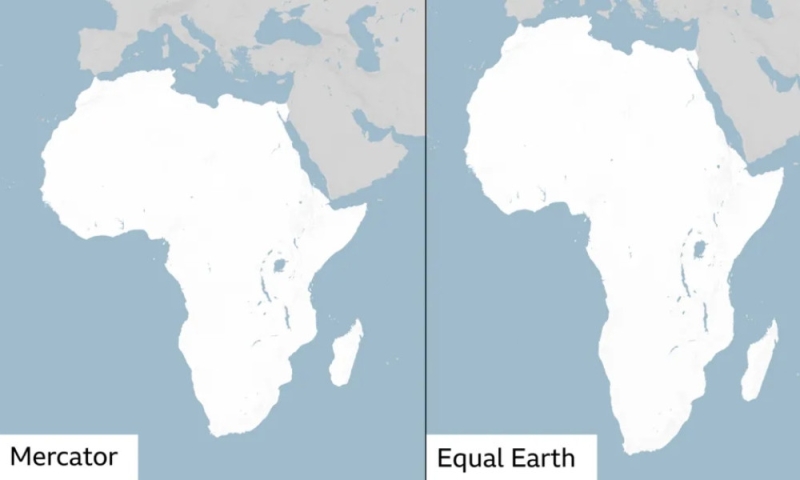
The United Nations General Assembly has endorsed a resolution calling for greater use of world maps that more accurately represent the relative size of continents, particularly Africa.
The resolution, spearheaded by Togo and backed by the African Union, promotes the use of the Equal Earth projection as an alternative to the widely used Mercator projection.
It was adopted with 164 countries voting in favour, six abstaining and the United States voting against. The resolution is not legally binding but encourages UN member states, international organisations, educational institutions and other stakeholders to promote more accurate cartographic representations.
The Mercator projection, developed by Flemish cartographer Gerardus Mercator in 1569, was designed primarily for navigation. While it preserves directions effectively, it significantly exaggerates the size of land masses as they approach the poles and makes regions closer to the equator appear relatively smaller.
One of the clearest examples is Greenland, which can appear comparable in size to Africa on a Mercator map. In reality, Africa is about 14 times larger than Greenland.
The Equal Earth projection, developed in 2018, is an equal-area map that represents continents in proportion to their actual surface areas while maintaining recognisable shapes.
Supporters of the initiative argue that the widespread use of distorted maps has contributed to misconceptions about Africa’s geographical scale and place in the world.
Togo’s Foreign Minister Robert Dussey described the initiative as part of a broader effort to promote a fairer and more accurate understanding of global geography.
The African Union welcomed the UN vote, calling it an important step toward fairer cartographic representation.
The United States was the only country to oppose the resolution, describing it as an ideological initiative that distracts the UN from more pressing global challenges.
The resolution does not eliminate the Mercator projection, which remains useful for maritime navigation. Instead, it seeks to encourage wider adoption of equal-area projections such as Equal Earth in education, public communication and other general-use contexts.