
- Rooppur NPP: Rosatom installs automated control system at Unit-1 |
- Mount Everest season opens late, despite huge ice block, high travel costs |
- 2 more children die with measles-like symptoms in Sylhet |
- Dhaka again ranks world’s most polluted city Friday morning |
- Speed up nationality verification for ‘illegal’ migrants: Delhi |
Sad Plight People in Bangladesh’s Teesta Basin
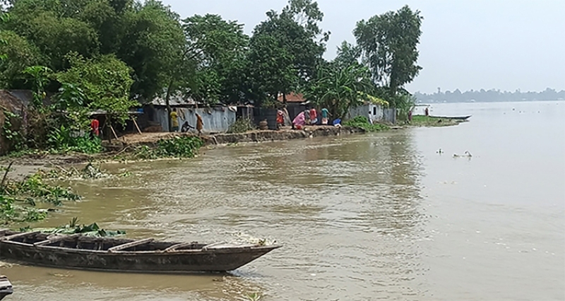
On a sunburnt afternoon along the Teesta’s braided channels, the people who have lived and laboured on its banks for generations gathered to tell their story in different words: the river has taken away their land, their livelihoods and their dreams. What remains is dilapidated homes, torn tin roofs, abandoned fields turned sandbars, and a weary determination that a permanent solution to their plight must finally be put in place.
This correspondent recently had a reporting trip through the Teesta basin and found a pattern repeated from village to village. Men and women, some bent with age and some hardened by repeated displacements, described the lives lived on the edge of seasonal catastrophes.
“We don’t argue about who will implement the Teesta Master Plan,” said Hazrat Ali, 55, a farmer from Tepakharibari upstream of the Teesta Barrage in Bangladesh. “We simply want a permanent remedy to the sufferings this river keeps giving us.”
Hazrat Ali’s words were not abstract. He pointed to a broad sweep of the river that, over the years, had swallowed his ancestral homestead. “Nodi hamak kheye feleche. Nodi hamar jomi jayga sob vangi ni gaiche,” he said in the local colloquial — the river has eaten us; it has washed away all my land. Once the centre of his family’s life, the current channel now slices through what used to be his fields. “Twenty bighas of land are gone,” he added, fingers tracing an invisible boundary that now lies deep under Teesta’s waters.
Across the region, similar stories surfaced. Shahidul Islam, 55, in Baniyarghat, described living in constant dread of flood gates being opened at Gazal Doba Barrage in West Bengal, India to release sudden torrents. “Floods come five or six times a year,” he said. “We lose homes, harvests, cattle. When it rains, we don’t rejoice — we get afraid.” Families climb to local embankments in search of shelter more times than they can count, losing possessions and dignity.
Older residents remember a different river before the Teesta barrage’s construction in 1990. Hazrat Ali, 75, of Char Goddimari in Hatibandha Upazila, said roughly eight bighas of his land vanished after the Teesta Barrage altered the river’s course. “If the Teesta is dredged and its flow restored, the lands of our forefathers would reemerge and we could farm them again,” he said. For many living in the submerged river margin, that possibility mixes hope and longing for a way back to a stable life.
The human toll is visible and raw. Nurul Islam, Fulchan Miah, Hasan Ali, Dulal Hossain, Abdur Rashid, Abu Bakar Siddiq and dozens more in villages like Nij Goddimari, Daskhin Sonakhuli Junagach and Doani told of repeated relocations forced by riverbank erosions. Families who once cultivated tens of bighas now live in torn tin sheds, raising small kitchen gardens on borrowed plots. Md Lalchan, a father of five, said the river took all of his 15 bighas of land, leaving him landless.
The river’s seasonal moods only make life more precarious. In the monsoon the Teesta swells into a powerful force that reshapes banks and carves away entire villages; in the dry season it shrinks, leaving wide exposed sandbars, poor flow, and little fish. Fishermen complain of dwindling catches; farmers complain of drought when water is needed most. “We are flooded when we don’t want water,” one villager said, “and left high and dry when we do.”
The media tour organised by the International Farakka Committee, Bangladesh, found what locals had been saying was true. From the Teesta Barrage point where the river spans about 600 meters to places where its width fans to several kilometres, the river shifts unpredictably. At Sindurna the channel can extend to nine kilometres; locals estimate an average width of five to six kilometres in parts of the course. Much of the river bed is heavily silted and sections appear nearly deserted during low flow.
According to led Prof. Dr. Md Sirajul Islam of the Civil Engineering Department and Director of the Centre for Infrastructure Research and Services at North South University who accompanied the journalists in the tour, the river has been heavily tamed mostly along its Indian part, starting from its origin at Sikkim with multiple dams and later extensive water withdrawal at Gazal Doba barrage site, just upstream of the Bangladesh border. This led to lowering of flow during dry season as almost nil, which led to extensive sedimentation forming bars and shoals within the river’s reach. In the monsoon, when all the gates of those Indian dams or barrages are open, the water is obstructed by those bars and shoals and divided into multiple streams, attacking the banks of the river.
Official figures are hard to find, but local advocacy groups estimate staggering losses. A top leader of the Teesta Bachao Nodi Bachao Sangram Parishad, said some estimates indicate annual property losses of up to Tk 10,000 crore, displacement of about 50,000 people, and crop damage on roughly 10,000 hectares of land. Whether these numbers are precise or indicative, they signal a crisis that combines immediate humanitarian consequences and long-term economic decline.
Technicians and engineers point to the Teesta’s unique hydrology to explain how and why these repeated disasters occur. Amitav Chowdhury, Executive Engineer of Bangladesh Water Development Board at the Teesta Barrage in Dalia, calls the Teesta a “flashy” river: its slope is steep — roughly 37 centimeters per kilometer, compared with 6–7 centimeters per kilometer for larger lowland rivers like the Padma or Meghna. This steep gradient accelerates flows during the monsoon, increases the river’s capacity to erode banks, and contributes to heavy sediment transport and deposition. Over time, the river bed becomes armoured and silted, choking channels, changing courses, and amplifying erosion.
For engineers, the solution seems straightforward: a comprehensive intervention that combines dredging, construction of embankments where necessary, and regulated reservoirs that can buffer the river’s extremes. Some villagers said they had heard of Chinese interest in a mega-project combining dredging, embankments, and a reservoir — measures they believe could bring an end to their sufferings. Local leaders and many residents insisted that the Teesta Master Plan — a long-discussed comprehensive project — must be implemented to bring relief from disasters.
Yet the proposals are not without controversy or complication. According to Prof. Siraj, solving a water related problem has never been straightforward and simple. More than technical expertise, it needs indigenous know-how to capture and consultation with local people for a bottom-up approach. Every solution here is different, and needs to be addressed case by case, having a deep understanding of the topography, climatology and hydrological behaviour of the river. He also emphasized that instead of a peace-meal solution, the issue needs to be addressed in a holistic manner.
Actually, river training with large-scale dredging and embankment construction can bring unintended consequences: altered sediment flow downstream, impacts on fisheries and wetlands, and displacement from construction itself. Any comprehensive plan must therefore consider transboundary hydrology, environmental safeguards, and the livelihoods of communities who depend on the river in its natural and modified states.
Still, villagers in Patgram, Hatibandha, Kaliganj, Lalmonirhat Sadar, Dimla, Jaldhaka, Gangachara, Kaunia, Pirgacha, Rajarhat and Sundarganj — areas mapped along the Teesta corridor — spoke with a rare unanimity: they want a durable fix. They hope a properly designed and implemented Teesta comprehensive project would halt bank erosion, restore farmland, provide irrigation and stabilize fish stocks. They are less concerned with the institutional or political details than with a tangible end to the cycles of destruction and displacement.
For many, the problem has a human edge that statistics cannot capture. A mother who had lost her home and watched the river take her brother’s land framed the stakes simply: “We don’t want charity; we want our land back and the right to live here without fear.” Children born into this instability learn to fear the sound of the monsoon first, then to build their lives sideways — migrating for seasonal work, schooling haphazardly, and growing up with a steady undercurrent of loss.
Experts say a viable path forward would combine immediate protective measures and a phased master plan focused on channel regulation, managed dredging, embankments where appropriate, and small- to medium-scale reservoirs to regulate flow. Equally important, they say, are community-based approaches that include fair compensation, legal recognition of land rights where possible, livelihood support during transitions, and participation of local people in planning and maintenance — so that technical fixes do not become social wounds.
The river’s course is ultimately shaped by water and sediment, but its future can also be shaped by policy, science and political will. The Teesta’s origin is the Tso Lhamo Lake fed by the Teesta Kangse glacier in the Sikkim Himalayas. From there it travels nearly 414 kilometres, nearly a half of it in Bangladesh, cutting through India’s West Bengal before entering Bangladesh’s Rangpur Division and finally joining the Brahmaputra. That long path crosses borders and communities, reminding planners that any lasting solution will require cooperation, robust environmental review, and attention to both upstream and downstream impacts. (This story has been published in the March print edition of the GreenWatch)