

- 8 Killed in Ashulia Garment Factory Fire |
- Apratim Murder Suspects Confessed, Says Home Minister |
- Dhaka's air decorded unhealthy for sensitive groups Sunday morning |
- Meet Earth’s newest wild cat species, the first named in over a century |
- Bus torched in Mymensingh early Sunday |
Why Dhaka Keeps Flooding Every Monsoon
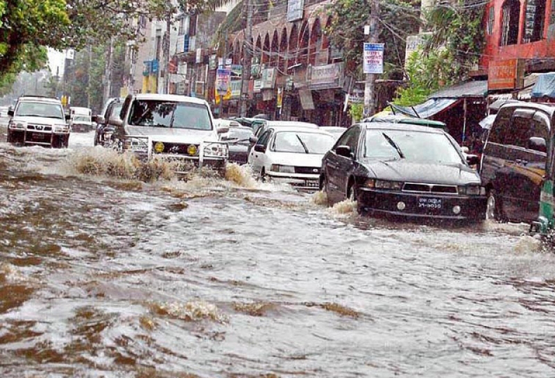
Downpours flood the streets of Dhaka.
Dhaka’s recurring monsoon flooding is often treated as a natural disaster, but rain is only the trigger. The deeper causes lie in poor planning, wetland loss, canal encroachment, unplanned urbanisation, weak enforcement and fragmented institutions. Dhaka is not flooding simply because it rains; it is increasingly vulnerable because the city has been built without adequately protecting the natural systems that once managed excess water.
Historically, Dhaka was part of a landscape of rivers, canals, ponds, floodplains and low-lying retention areas. These were not vacant spaces. They functioned as natural drainage infrastructure, storing rainwater, slowing runoff and carrying excess water toward surrounding rivers. As the city expanded, many of these areas were filled, narrowed or disconnected, leaving drainage systems struggling to cope with heavy rainfall.
Urbanisation has worsened the problem by replacing absorbent land with concrete. Roads, buildings and paved surfaces reduce water infiltration and accelerate runoff. A 2023 study on pluvial flooding in Dhaka found that changes in land use have depleted natural canals and increased flood vulnerability, with future inundation likely to worsen if urban expansion continues.
The deterioration of drains and canals has further weakened the city’s ability to manage rainfall. Many waterways are clogged with waste, narrowed by illegal structures or disconnected from smaller drainage channels. In some areas, box culverts have buried waterways instead of restoring them as functioning drainage corridors.
Climate change is adding further pressure through shorter, heavier and less predictable rainfall. But climate change should not become an excuse for poor planning. Dhaka’s vulnerability is also the result of reducing its own capacity to absorb and manage water.
The consequences are felt across the city, particularly when major roads in areas such as Mirpur, Dhanmondi, Green Road, Motijheel, Shantinagar and Old Dhaka become submerged. Public transport slows, commuters lose hours, businesses suffer and vehicles and goods are damaged. Flooding also causes lost productivity and significant disruption to everyday life.
The burden is even heavier for low-income residents living in informal settlements and low-lying areas. Floodwater mixed with sewage, waste and pollutants can enter homes, damage belongings and increase exposure to waterborne diseases. Residents with limited savings and access to healthcare are less able to recover from repeated flooding.
A 2023 GIS and remote-sensing study found that almost 35 percent of Dhaka falls within high- or very-high waterlogging vulnerability zones, with slum households disproportionately concentrated in vulnerable areas. Recent heavy rainfall has repeatedly demonstrated the scale of the problem, with major parts of the city becoming waterlogged despite substantial investment in drainage infrastructure.
Infrastructure spending alone, however, has not produced sufficient resilience. The two Dhaka city corporations reportedly invested more than Tk 262 crore over four years up to 2024 to build 334.19 kilometres of drains, box culverts and related infrastructure. Yet large parts of the city continue to flood.
Planning data also show the scale of ecological loss. Dhaka reportedly lost 3,440 acres of designated flood-flow zones, retention areas and waterbodies between the 1995 Detailed Area Plan and subsequent development. Central-city waterbodies have also declined dramatically. The city is therefore spending money to drain water while allowing the natural systems that make drainage possible to disappear.
Institutional fragmentation compounds the problem. Dhaka WASA, the two city corporations, RAJUK, the Bangladesh Water Development Board and other agencies each control different parts of the drainage and land-use system. Yet no single authority manages the entire catchment, including drains, canals, retention areas, pumps, river outfalls and land-use controls.
Weak enforcement makes the problem worse. Master plans and Detailed Area Plans have identified flood-flow zones, retention ponds and wetlands, but these areas continue to be threatened by housing, roads and commercial development. Where regulations are not properly enforced, short-term development gains create long-term costs for the wider city.
Dhaka therefore needs more than another drainage project. The city must treat canals, wetlands, ponds and flood-flow zones as critical public infrastructure. Remaining wetlands should be protected, encroached canals demarcated and restored, and waterways reconnected with surrounding rivers.
An integrated flood-management system is also needed, with clear authority over land-use approvals, canal restoration, drainage investment, pump operations, solid-waste management and emergency response.
Future planning must place vulnerable communities at the centre of flood resilience. Informal-settlement residents, low-income households, street vendors, schoolchildren and daily-wage workers often suffer the greatest losses but have limited influence over urban planning. Community-based reporting of blocked drains, health warnings, emergency transport arrangements and support for people facing repeated losses should therefore become part of the city’s resilience strategy.
Dhaka’s flooding is ultimately a warning about planning against nature. The city has tried to engineer its way out of a crisis created partly by land conversion, institutional weakness and ecological neglect. Until Dhaka restores and protects its blue-green network as essential infrastructure, every monsoon will bring the same question: why does a megacity continue to struggle with water it once knew how to manage?
The choice is no longer between development and drainage. It is between sustainable urban development and repeatedly paying the price for ignoring nature.