

- Tarique Put Bangladesh’s Interests First at UN: Mahdi |
- Crackdown on extortionists, criminals to be intensified : Home Minister |
- Trump says top tech firms have signed accord to 'self-police' AI dev |
- France Student Protests Spread Nationwide, Over 400 Detained |
Protect Himalayan Region from Cascading Disasters
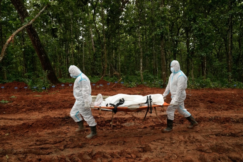
Nepals paramilitary force personnel carry the body of a flash flood victim for burial at a mass burial site in Chitwan, Nepal, Monday, Aug. 31, 2026. Photo- AP-UNB
By SANDRP on September 7, 2026
In the wake of the Aug. 26 Nepal disaster, civil society groups in India have demanded urgent measures to protect people, mountains and rivers from increasingly complex and cascading disasters across the Himalayan region. The statement issued under the umbrella of People for Himalaya rightly appeals for high-altitude and trans-Himalayan areas to be treated as no-go zones for high-risk mega infrastructure projects, including large hydropower projects.
The statement also underlines that large dams, tunnels, roads, tourism and urban expansion are already reshaping rivers, slopes and valleys across the Himalayan region. Rebuilding damaged infrastructure and new projects in the same inherently fragile, vulnerable areas can further increase exposure to future disasters and compound risks. Notably, similar demands have also been raised in past two weeks by concerned local communities and experts across the Teesta, Brahmaputra, Chenab and Sutlej basins.
The larger message of the statement is that we urgently need to move away from a project-centric development model that contributes to recurring and catastrophic disasters. The rapid, unabated expansion of projects in the Himalayas, without adequate assessment of cumulative risks, has been acting as a force multiplier for disasters. A
t present, we remain largely reactive, focusing on post-disaster response rather than preventing and reducing risks. This must be changed through risk-sensitive planning, ecosystem protection and stronger regional cooperation. The sooner we listen to Himalayan warnings and concerned voices; the lesser will be the risk and impact of disasters in future.
Make the Himalaya a ‘no-go zone’ for high-risk mega infrastructures The statement also emphasised that the safety and rights of workers, including migrant workers, employed in tunnels, hydropower projects, construction sites and other high-risk infrastructure should be protected through mandatory risk assessments, emergency preparedness, evacuation protocols, communication systems and safe working conditions.
Himalayan Floods Are a Debris Event Parineeta Dandekar here explains how Himalayan floods are dominated by debris flow rather being just a water flow. But all our dam designs, dam safety, spillway capacities, river carrying capacity and other such assessments are essentially assuming water flow. These floods are geo-morphological event rather than just a meteorological event. Are our dams even safe in that context? Are we ready for their reassessments?
SANDRP argues that the failure to grasp the true physical nature of these floods represents a systemic blind spot in South Asian engineering and environmental governance. As the youngest mountain range on Earth, the Himalayas naturally function as a massive sediment conveyor belt driven by ongoing tectonic uplift, monsoonal downpours, receding glaciers, and melting permafrost.
Highlighting what it terms regulatory complacency, SANDRP points out that authorities recently granted environmental clearances to rebuild projects like Teesta 3 on the same vulnerable footprint using original impact assessments with only modified spillways, alongside approving new projects beneath unstable glacial lakes in Himachal Pradesh and Jammu. The organization cautions that until engineering standards pivot from a purely hydrological view of water flow to a geomorphological understanding of mass debris movement, infrastructure built in high-altitude valleys will continue to exacerbate catastrophic destruction and human casualties.
Bearing witness: the making of Himalayan Disaster In this recorded webinar, Bearing Witness: The Making of Himalayan Disaster, we reflect on the recent disasters in Nepal and Tibet and examine how climate change, infrastructure development, extraction and political decisions are reshaping hazards, risks and vulnerabilities across the Himalayan region. The Himalaya is not simply a landscape of “natural disasters”. Across the region, communities are experiencing the combined impacts of a changing climate and development interventions that have transformed rivers, forests, valleys and local ecosystems.
NEHR urges CM to review hydro projects downstream of high-risk glacial lakes In a letter to the CM, NEHR chairperson Ebo Mili, while reminding the CM of an earlier representation submitted in February 2024 regarding the growing threat of GLOF in Arunachal Pradesh, said “the recent glacial lake outburst disaster in Nepal, triggered by the collapse of glacier ice, is deeply saddening and serves as a stark warning. Yet India continues to ignore the same threat on our own soil.”
Stating that Arunachal is ringed by glacial lakes, the NEHR chairperson said that the National Disaster Management Authority (NDMA) has long classified many of these lakes as high-risk under Categories A, B and C, with Category A posing an immediate threat. Several of these lakes lie barely 30-50 km from the nearest road and inhabited areas, the NEHR said. The NEHR further said that in 2024, the State Disaster Management Authority itself had conducted a survey of glacial lakes and confirmed the danger by flagging many of them as very high risk.
The district-wise figures are alarming, the NEHR said, and added that Dibang Valley district has 16 glacial lakes flagged as high risk, while Anjaw has three, Tawang six, Kurung Kumey one, and Shi-Yomi one. “Despite clear and present danger, both the state and central governments continue to aggressively push mega hydropower projects located directly downstream of these high-risk lakes,” the NEHR said.
The NEHR chairperson stated that the 3,097 mw Etalin hydroelectric project is situated only about 38 km downstream of Category A glacial lakes and the 1,200 mw Kalai-II project in Anjaw district lies just below Hawai, with Category A lakes barely 30 km away. The NEHR further said that Tato-I and Tato-II projects in Shi-Yomi district stand in close proximity to high-risk glacial lakes.
SIFFYW says Siang villagers reaffirm opposition to mega dam The Siang Indigenous Farmers’ Forum Youth Wing (SIFFYW) in Upper Siang district said that thousands of villagers opposed the proposed 11,000 MW Siang Upper Multipurpose Project (SUMP) during an “unofficial meeting” held on 27 August.
The organisation said that villagers are also deeply concerned about a glacial lake measuring approximately 8.18 hectares, classified as Category A by the National Disaster Management Authority and located about 25 km from Tuting. “The proposed 11,000 MW Siang Upper Multipurpose Project lies directly downstream of this lake. Locals describe the decision to build such a massive project in this location as reckless and deeply inconsiderate of the Adi community’s safety and future,” the organisation claimed.
It said the proposed dam site lies in seismic Zone V, a highly fragile and active earthquake zone. Villagers have expressed deep fear that constructing a massive reservoir holding billions of cubic metres of water in such a region is an invitation to catastrophe, the organisation said.
Why the Nepal disaster is a warning Arunachal Pradesh cannot ignore The Nepal disaster underscores a hard truth: infrastructure built without rigorous, cumulative risk assessment — one that accounts for climate projections, multi-hazard cascades, and ecological limits — can become a liability rather than a resilience asset. Poor maintenance, underfunded restoration, and gaps in early-warning systems only make outcomes worse.
Treating the Nepal tragedy as a wake-up call means shifting from reactive recovery to proactive risk reduction — one that prioritises ecological integrity alongside resilient, not merely expanded, infrastructure. Failing to do so only raises the probability that the next major debris flow or GLOF will strike Indian territory with comparable, or greater, human and economic cost. (Neha Desai)
Sikkim Body Urges PM to Scrap Hydro Projects The Sikkim Bhutia Lepcha Apex Committee (SIBLAC) appealed to Prime Minister Narendra Modi to freeze all new hydropower initiatives in the state and commission an independent, time-probe investigation into projects already operating there.
Tseten Taski Bhutia, SIBLAC’s convenor and also chief advisor to the Bharatiya Janata Party’s Sikkim unit underlined that the floods in Nepal suggest “a fresh assessment of development activities” is required. “The disaster in Nepal highlights the vulnerability of the Himalayan region, requiring a fresh assessment of development activities,” he said, adding that the Union government needed to rethink its plans for further hydroelectric development on Sikkim’s rivers.
Bhutia also pressed for a thorough, independent review covering the environmental, geological, seismic, social, and national security dimensions of every hydropower project in Sikkim, both existing and proposed, and asked that the government release a white paper detailing the outcomes of this assessment.
Melting glaciers in the Eastern Himalayas, large hydropower dams in Tibet, Bhutan and even locally and the growing impact of climate change has raised alarms in the ecologically sensitive Northeastern region with experts and activists calling for urgent steps to prepare for a Nepal-like disaster.
Nepal flood: Warning for J&K’s hydropower expansion Experts argue that J&K should consider a temporary pause on fresh large hydropower commitments to allow an independent cumulative reassessment of Himalayan safety. Such an assessment, they say, should go beyond the conventional project-by-project approach. A river basin is an interconnected ecological and geological system.
Experts therefore call for cumulative assessments examining what multiple dams, tunnels, access roads, blasting, slope cutting, muck disposal and transmission infrastructure together mean for a basin. Such an assessment should map glaciers and potentially dangerous glacial lakes upstream, reassess landslide and seismic vulnerability, examine extreme-flood assumptions and determine whether dam and tunnel designs remain adequate under changing climatic conditions.
Experts also stress that construction-phase risks deserve greater attention. Tunnelling, blasting, road cutting and disposal of excavated material can alter slopes and drainage patterns, potentially increasing vulnerability in already fragile terrain.
At a meeting on Sept. 01, Union Home Secretary Govind Mohan called for “continuous and proactive monitoring” of vulnerable glacial lakes and avalanche-prone areas and said warnings must be “acted upon promptly and effectively”. He also called for a shift from “response-oriented measures towards risk-informed planning, preventive mitigation and community-level preparedness.” The directions come days after a massive glacier-related disaster in Nepal damaged hydropower infrastructure and left hundreds of workers missing in the country’s Trishuli valley.
Kashmiri geoscientist Irfan Rashid is using satellite imagery of Nepal’s recent catastrophic floods to decode how massive glacier-ice collapses trigger deadly downstream events. By analysing Landsat, Planet and Sentinel data, he links this disaster to broader Himalayan risks, arguing that science-based, pre-emptive planning is vital as glacial lakes expand and climate-driven hazards intensify across Kashmir and Ladakh.
More Himalayan disasters are already being built Across the Himalayan states of India and Nepal, unregulated construction has turned river valleys and unstable slopes into death traps. The human and developmental costs of Himalayan disasters will continue to multiply unless we act. First, there is an urgent need for strictly enforced restrictions on construction in high-risk zones. Not blanket bans – those are unrealistic – but rigorous, enforceable standards backed by risk-sensitive land-use planning.
The NDMA has already emphasised that construction practices must undergo rigorous evaluation and building regulations require updating and reinforcement. That recommendation must become law, with independent oversight and penalties for violations. The other involved nations must follow.
Second, hydropower safety standards must be redesigned for catastrophic flood scenarios, not historical averages. Independent audits of all existing and planned projects are non-negotiable. Energy security depends on resilient infrastructure, not just installed capacity. The NDMA has rightly called for the environmental effects of hydro projects to be assessed cumulatively in river basins, and for standard operating procedures to be developed for disaster response at project sites.
Third, we must have a trilateral monitoring and early warning agreement between India, China and Nepal, with realtime data sharing and funding tied to compliance. ICIMOD has warned that we are trying to navigate a rapidly changing future with an incomplete map. That map must be completed, and it must be shared. (Soumya Sarkar)
The Mountains Warn, the Rivers Carry the Warning The greatest mistake now would be to treat Bhote Koshi as another natural disaster, issue condolences, announce relief, rebuild what was destroyed and wait for the next mountain to fall. The next mountain may fall in Sikkim. The next barrier lake may form somewhere else. The next flood may travel into Bangladesh. And the next cascading disaster may make Bhote Koshi look like a rehearsal.
The Himalayas have already given us the warning. The question is whether South Asia will finally understand what the river has been telling us. A disaster that begins upstream does not belong to the country where the mountain happens to collapse. The mountain has no passport. The glacier has no border. The river has no nationality. And the people downstream have no choice. So how many more warnings must the mountains send before we finally listen? (Prakash Dahal)
Why Nepal floods should worry India As permafrost degrades, glacial lake outbursts and rock-ice avalanches are expected to increase, producing faster, debris-laden floods that are harder to forecast. And more extreme events mean more landslides and sediment in rivers, raising riverbeds and reducing channel capacity on both sides of the border. They are manifestations of the same broad Himalayan hazard system. And India’s exposure is considerable. Though the role of climate change in this incident is still being debated, the science is clear: signs of climate change have shown up across the Himalaya, from shrinking glaciers to thawing permafrost.
Nepal flood is a warning that disaster planning must prepare for chains of hazards, not isolated events, say experts. Nepal, Rishiganga and Dharali are signals of a Himalayan crisis (Jay Singh Rawat) Kedarnath, Chamoli, Sikkim, Thame and Nepal have faced devastating high-altitude disasters in recent years. But their causes differ, raising a bigger question about how Himalayan risks are changing.
HYDRO POWER PROJECTS
The unseen dangers of China’s mega dam on Brahmaputra China’s Great Bend Hydropower Project on the Yarlung Tsangpo river poses a significant threat to downstream nations like India due to its construction in a geologically fragile and disaster prone region. By Himanshu Thakkar-SANDRP.
India-China water talks must look beyond hydrological data The countries should consider combined hazard monitoring as well as risk assessment, and invest more in scientific studies and research, even if these may be in contravention of the hydropower plans that both countries have for their vast water resources in vulnerable locations such as Arunachal and occupied Tibet. (Tongam Rina)
Global financial institutions ‘ignored’ warnings in Nepal’s hydropower disaster According to an extensive investigation published by the SANDRP international financiers—including the World Bank Group’s International Finance Corporation (IFC), the Asian Development Bank (ADB), the Asian Infrastructure Investment Bank (AIIB), and the Export-Import Bank of China—pushed forward major hydropower projects in disaster-prone valleys despite documented warnings, recurring historical floods, and unheeded safety recommendations.
As Dandekar and Thakkar (SANDRP), noted, a “cumulative impact assessment” of the Trishuli basin, published by the International Finance Corporation in 2020, analysed potential environmental and social impacts of hydropower across the entire the basin, but did not discuss the threats of glacial lake outburst floods and flood disasters. While it looked at the fragmentation of aquatic habitat, reduced water availability and impacts on river-based livelihoods in the basin, which has more than 36 hydropower projects, “It did not even attempt to look upstream and assess Tibetan impacts,” they wrote. “It made no cumulative disaster plan for a basin littered with hydropower projects.”
450 MW Baglihar capacity down What was announced as a one-day shutdown for desilting at the Baglihar Hydroelectric Power Project has turned into a prolonged outage, with its 450-MW Stage-I remaining non-operational for the 18th day amid heavy accumulation of silt at the gates.
The prolonged shutdown has effectively reduced generation at the 900-MW Baglihar project by half, leaving only Stage-II, with a capacity of 450 MW, in operation. Desilting and silt-flushing operations at Baglihar began on August 18. While Stage-II was restored on August 22, Stage-I has remained out of operation because of silt accumulated around its gates, according to officials familiar with the development.
The sources attributed the situation to alleged mismanagement in the handling of the desilting exercise and said an operation involving such a critical power project required much more careful planning. A senior official associated with the ongoing restoration work said the problem was now technically difficult and potentially hazardous because of the extent of the accumulated silt.
“Our gates are five metres high, but the silt is around eight metres high,” the senior official said. This means the accumulated silt has reached around three metres above the height of the gates, considerably complicating the task of clearing it.
The official said the accumulation had taken place with the passage of time during the silt-flushing process and that engineers could not attempt to clear it hastily because of the risks involved. “It is a very risky job. We have to take precautions,” the official said. He said the high water level in the Chenab was adding another layer of difficulty to the operation.
With the water level remaining high, the teams working on the project have to balance the requirement of removing the accumulated silt with the safety of personnel and equipment, making the restoration process both technically and operationally challenging. The official also clarified that the problem was not restricted to one gate, indicating that the accumulation had affected a wider portion of the flushing system. “Work is going on, but I think it will take more than 15 days,” the official said while explaining the difficulties involved in restoring the affected 450-MW capacity.
DAM SAFETY
HP: Safety gaps in 3 dams, 12 are high hazard Twelve of Himachal Pradesh’s 15 operational dams under the State Dam Safety Organization (SDSO) have been placed in Potential Hazard Category-I, while three have been classified in Category-II following the detection of deficiencies requiring continued monitoring and remedial measures. The findings are part of the Annual Report on Dam Safety–2025-26 of the State Dam Safety Organization, prepared by the Directorate of Energy under the provisions of the Dam Safety Act, 2021. The report was tabled in the Vidhan Sabha on Sep 3 2026.
The report documents annual inspections, safety reviews, evaluations and compliance with statutory requirements. While the majority of the dams were found to be functioning satisfactorily, Giri Jateon barrage and the Malana-I and Malana-II hydel projects were placed in Category-II due to deficiencies requiring sustained monitoring and timely corrective action. The deficiencies identified in these three projects include the need for structural rehabilitation, completion of spillway works, restoration of non-functional instrumentation systems and strengthening of emergency preparedness arrangements.
The report has also highlighted the need to make dam safety systems more climate-resilient in view of the increasing frequency and intensity of climate-related hazards. Himachal currently has 26 commissioned dams, besides four under construction and one under commissioning. Of these, 17 fall under the jurisdiction of the SDSO-Himachal Pradesh. Eleven of these are owned by private power producers, while six are owned and operated by government agencies.
DAMS
Polavaram: PIL in AP HC by retired IPS for review The Andhra Pradesh high court on Aug 31 adjourned the hearing of a PIL filed by retired IPS officer AB Venkateswara Rao, seeking the constitution of an independent committee of technical and structural engineering experts to examine key construction components of Polavaram project, including the diaphragm wall, ECRF dam foundation structures, design changes, and quality aspects in gap-1 and gap-2.
Rao pleaded that the authorities concerned be directed to submit all records pertaining to quality tests conducted on the diaphragm wall, daily concrete pouring details, and slurry test records to the court. He also sought a direction restraining authorities from undertaking any further construction activity in gap-2 ECRF dam foundation zone until the expert committee submits its report. He urged the court to order independent field-level investigations, including core drilling and non-destructive testing. The court adjourned the matter.
TN farmers announce 5-day statewide stir against Mekedatu dam project Tamil Nadu farmers will launch a five-day statewide agitation from September 20 against Karnataka’s proposed Mekedatu dam across the Cauvery, the Coordination Committee of All Farmers’ Associations of Tamil Nadu announced on Sept. 04. Its president, P R Pandian, announced the protest after a five-hour meeting between a delegation of farmers and Union Minister for Power Manohar Lal Khattar in Gurugram.
Pandian said the DPR had been submitted without the required consent of Tamil Nadu, Puducherry and the Cauvery Water Management Authority (CWMA). He urged the Centre not to grant environmental or forest clearances for the project, arguing that the proposed dam would adversely affect farmers in both Karnataka and Tamil Nadu.
According to Pandian, farmers in Karnataka have also acknowledged that the project would not benefit them because the proposed dam site is located deep inside a forested area downstream of the Krishnarajasagara (KRS) dam. As an alternative, Pandian suggested constructing a dam at Rasimanal in Tamil Nadu. He claimed that farmers from Tamil Nadu and Karnataka had reached a consensus on the site during a joint meeting in 2024 and urged the Centre to allow the project.
Gangavali River faces growing water stress Water pumped from a station near Honnalli in Ankola is supplied to Ankola town, Karwar city, the Kadamba Naval Base, Grasim Industries at Binaga and 13 gram panchayats. The daily requirement is 21 million litres. “Supplying drinking water from the Gangavali until February is not very difficult. After that, storing water by constructing a sandbag barrage becomes challenging for three months. In recent years, during peak summer, the water level has fallen so low that supply had to be stopped,” said an official of City Water Supply Board.
The second-phase expansion of the Kadamba Naval Base is almost complete. It currently receives eight million litres per day (MLD), but this could rise to 21 MLD within months. If an airport comes up at Alageri, supply will have to increase further. Within a few years, more than 45 MLD may have to be supplied from the Gangavali, the official added. Construction of a weir to store summer water in the Gangavali is 36% complete, said City Water Supply Board Executive Engineer Shivarama Naik.
“We aim to complete it by June next year. Stored water will be supplied to Karwar and Ankola, while the naval base will receive water through a separate pipeline,” he added. Water levels in the Gangavali remain high only during the four monsoon months and are very low for the remaining eight months. The flow will decline even before summer. If the river diversion project is implemented, it could harm the environment and leave people in Karwar, Ankola and Gokarna without adequate water, said Save Gangavali-Karavali Awareness Campaign president Ananth Hegde Ashisara.
If water from Gangavali River, the lifeline of the coastal region, is diverted to Haveri district, the reduced flow will destroy the environment and agricultural activities in riverside villages of the Ankola area. People in Karwar, Gokarna and Ankola will struggle for drinking water. Seawater will intrude deep into inland areas, causing the destruction of aquatic life and adversely affecting fishing. Hence, the voice of coastal people against river-linking projects must grow louder, he added.
India builds first rock dam in Ladakh India has built its first rock check dam across the river at Upshi in Leh. Made entirely of natural boulders and without using cement, the dam has raised the water level by nearly 10 feet, allowing farmers to irrigate fields that had long struggled for water during the spring sowing season. The new dam stores nearly 40 million litres of water and feeds dry village fields through the Igoo Phey irrigation canal.
The Ladakh administration is now working on more such check dams on the Indus River, with work underway at some locations and many more projects in the pipeline. The Ladakh Administration has submitted a proposal to the Union Ministry of Jal Shakti for the construction of 36 check dam projects in the Union Territory, in a move aimed at strengthening water security and expanding irrigation potential. The proposal includes seven Himalayan Rock Check Dams in the Leh region and 29 Check Dams or weirs in the Kargil region, at an estimated cost of over Rs 56 crore.
SANDRP
Source: https://sandrp.in/2026/09/07/drp-070926-protect-himalayan-region-from-cascading-disasters/